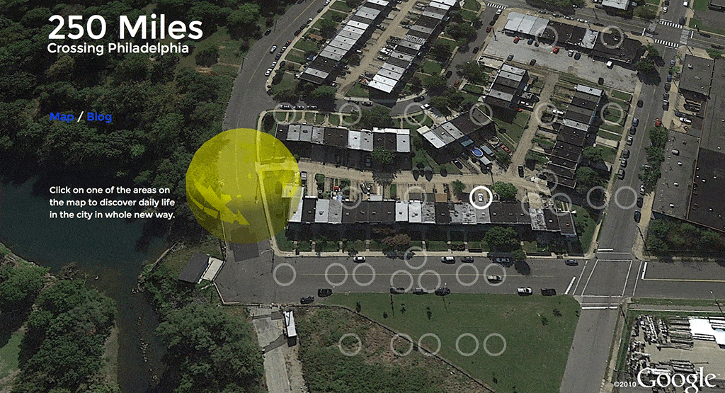
The interactive artwork 250Miles Crossing Philadelphia contains 27 stories told and portrayed by the same number of protagonists. People make their voices heard, tell stories about their lives, animals bark and neigh, vehicles honk, ring their bells or let their engines growl, some objects are just silent. All accompanied by sounds from their surroundings and seen in Google Earth. Let you lead into this urban adventure by clicking on the image.
The interface allows you to stop the track, for scrolling through the track and jump between tracks.
Philidelphia through movement
Dutch visual artists Esther Polak and Ivar van Bekkum lived seven months in Philadelphia. New to the city, they invited inhabitants, both human and non-human, to explain their city through movement. Wandering by themselves, the participants recorded their trajectories, sounds and private readings of the streets, allowing the artists and the audience to access their experiences only afterwards. The project positions the viewer, with the artists, as unwitting voyeurs.
A radical and innovative visual approach introduces a landscape of satellite images and balances between voyeurism and empathic co-traveling. This meditative experience questions our contemporary techo-society, where eavesdropping and social connectivity coexist.
First worldwide
250 Miles crossing Philadelphia led to the first experimental film worldwide solely based on the gps-trajectories and synchronized sound recorded in this project: Once We Get There. This film won an award for Best Concept in the 2Annas Film Festival in Riga and was shown at FID Marseille.
Based on the reception we went back to the studio and created a second film, A Collission of Sorts. This film screened in competition at The Netherlands Film Festival in 2017.
See also the filmography page for all films by PolakVanBekkum, trailers and links.
Obsolescence Note
Due to the speed of technical developments and changes, some online artworks turn out to be built on quicksand. When that happens, and there is no solution, to let go is inevitable.
On December 2014 Google decided to deprecate the Google Earth-plugin or API. This is something technical but it brought that the 250 Miles website did not longer function the way we intended it. This made us sad at first. Our intention was, that anybody could play the recordings we made directly in Google Earth in a browser. Meaning that one would be able to play around with the tracks in an interactive way. The API finally shut down in December 2015 . For some time it did still run in Firefox and Safari. Esther and Ivar both have different feelings about it, as their comments in the video tell. The video was based on screen shots we made.
Software developed/used
- MilkMachine02: open source custom build Python plugin for the open source GIS platform QGIS.
Developed in collaboration with Sean McGinnis and Edward Farrel. - Hardware build-in “The Beagle“
- GPS recording: QStarz GPS-recorders
- Sound recording: Nagra SD audio recorders, omni directional lavalier microphones, micro shotgun microphone, customised microphone wind covers.
- Podcast: An outdated ipod video and a new set of simple earphones for every participant …
- MilkMachine02 Software can be downloaded on this Github page.
Clip with an example of the functionality of MilkMachine02.
Related projects
We listed some other artistes and art projects that used the Google Earth API or closely related technologies. Please let us know if you know of any that should be mentioned as well.
Rafael Lozano-Hemmer used the Google Earth API in the of projects Vancouver Olympics in 2010 and Open Air
Garreth Lynch
Digital Detritus by Peter Root
Tectonic by Micah Frank
Andreas Broeckmann suggested the excellent work PicMe by Marc Lee from Switzerland:
Owen Mundy kindly suggested his work Camp-la-jolla: (project page) and the his interactive piece Drone_tracker_05:
Jodi’s GEO GOO: http://geogoo.net/
